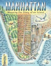
Told in dazzling maps and informative sidebars, Manhattan explores the 400+ year history of Manhattan Island.
From before its earliest settlement to the vibrant metropolis that exists today, the island of Manhattan has always been a place of struggle, growth, and radical transformation. Humans, history, and natural events have shaped this tiny sliver of land for more than 400 years.
In Manhattan, travel back in time to discover how a small rodent began an era of rapid change for the island. Learn about immigration, the slave trade, and the people who built New York City. See how a street plan projected the city’s future, and how epic fires and storms led to major feats of engineering above and below ground.
Through dramatic illustrations, informative sidebars, and detailed maps inspired by historic archives, Manhattan explores the rich history that still draws people from all around the world to the island’s shores today. From The Battery downtown up to Inwood, every inch of the island has a story to tell.---from the publisher
64 pages 978-1419736551 Ages 8-12
Keywords: New York, informational picture book, history, island, cities, 8 year old, 9 year old, 10 year old, 11 year old, 12 year old, maps
*************
“Skyscrapers and subways and stations
Staring up at the United Nations”
-- Alice Cooper, “Big Apple Dreamin’ (Hippo)” (1973)
Back when the city only occupied the southern tip of the island,
“The Collect Pond sat north of the city, fed by an underground spring. It was a kettle pond, scooped out from the land when the glacier that covered the island retreated more than twenty thousand years earlier. It was the island’s best source of fresh water. Two streams flowing from its east and west sides sometimes overflowed and split the island in half. For centuries, the area was home to the Lenape village of Werpoes.
By the 1700s, free Africans lived nearby. In those days, black people were not allowed to be buried in the public cemetery at Trinity Church since it was inside city limits, so they laid their loved ones to rest near the pond’s edge.
As the city on the island grew, breweries, tanneries, and slaughterhouses moved next to the pond. They dumped foul waste in its clear waters. A canal was dug to try to drain the putrid mess into the Hudson River, but the rise and fall of tides only sloshed the filthy water around. The stench was unbearable.
In time, the city decided to fill the pond and canal. The canal became Canal Street. They built fancy homes on top of what was once the pond and called it Paradise Square. But soon, gas from the decomposing landfill gurgled up. Buildings tilted and sank in the mud. The rich moved out, and poor people moved in.
By the mid-1800s, the neighborhood became known as Five Points, for the five streets that crossed the area. A jail called the Tombs was built nearby. Gangs roamed the streets. Murder and mayhem ruled. Some tried to make Five Points a better place for the people who lived there, but once again, the city tore everything down.”
I’ve always been entranced by Manhattan. My first memories of being there go back 55 years, to a morning when we piled off of a yellow school bus on our way to the American Museum of Natural History. I recall the then-gray sootiness that hung in the air and adhered to the buildings and the smells coming from the goods of street vendors, the chestnuts over charcoal, and soft pretzels.
A few years later, I began riding the train into Manhattan by myself or with friends, for school research projects, rock concerts, and visits to the so-called hippie stores then in abundance in the East Village.
Jennifer Thermes’s MANHATTAN: MAPPING THE STORY OF AN ISLAND, is a visual delight and a nonfiction treasure. A wealth of maps, each one a work of art, along with other captivating illustrations, provide details of the island’s evolution from home to oysters, beavers, and the Lenape Indians to present-day land of subways and skyscrapers. Along the journey, we encounter cultural, geological, and political events. There are discussions of slavery and other trading, the treatment of the native people, the obliteration of the island’s 60 million beavers, the fires, blizzards, skyscrapers, and parks.
Did you know that the island’s name came from the Lenape? The author notes that, “They called it Mannahatta, which means ‘island of many hills.’” These days, I live in San Francisco. I know about walking and driving up and down hills. So how have I possibly missed the hills of Manhattan?
It seems that the geography of a city can be deliberately and radically altered. After an 1811 city commission planned a grid system for new streets in the expanding city, the island’s hills were leveled. We learn that, “The canals were filled in, and the land expanded into the East River by filling it with rocks and earth, broken crockery, oyster shells, wood from old shipwrecks, rotting garbage, and even dead animals!” There are fascinating, if sometimes grotesque details about the changes upon changes that transformed Manhattan from a wooded wonderland to what it is today.
I’m flying back to Manhattan for a visit next month. It still feels like Wonderland to me. Thanks to Jennifer Thermes’s maps and historic details, I’m going to be wandering around with a whole new view of it.
Recommended by: Richie Partington, MLIS, California USA
See more of Richie's Picks https://richiespicks.pbworks.